
Pavement Management
Maximizing pavement life
The City of Vancouver maintains about 1,900 lane miles of paved streets. Pavement management is a way of protecting this community asset and maximizing the life of our streets.
Every year, we evaluate pavement conditions across the City and identify the most cost-effective methods for each selected street. When streets begin to fail, they fail quickly and the costs to repair them increase dramatically.
The City’s Street Fund, General Fund and license fees collected through the Transportation Benefit District provide the main source of funding for this annual program.
General timeline
Proactive pruning
The Pavement Management Program coordinates with Urban Forestry to care for and replant street trees. Tree and vegetation pruning begins in February and continues through June. New street trees are planted in the fall.
Proactive street tree pruning helps protect the health and structure of trees. Trees shading Vancouver streets cool neighborhoods and extend pavement life.
ADA curb ramps
Work usually starts in March or April. Federal requirements mandate that curb ramps be upgraded to current ADA-compliant standards along streets receiving treatments that are considered an alteration, such as paving or cape sealing. In areas where ADA-compliant ramps exist, no changes are required.
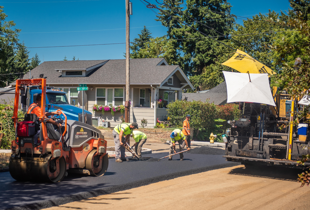
Pavement prep
Pavement crack sealing and repair usually take place from March through early July. In some areas, crews will mill off failed areas to prepare the street for pavement work.
Summer work
Resurfacing, rehabilitation and pavement preservation typically takes place from the middle of June through early September. Striping/pavement markings removed during street work will be reapplied after the surface is ready. Allow for curing time and weather conditions.
Rain and other conditions can affect schedules. If work is delayed due to rain or other issues, you will receive a new notice prior to work taking place.
Schedules
St. Johns Road curb ramps
ADA curb ramp construction on St. Johns Road starts in early June. New elements, including ADA curb ramps, curbs, sidewalks, and pedestrian push buttons, improve mobility and accessibility for all users of our streets. We’ll be adding over 30 curb ramps. Work is expected to finish in late August.
Schedules may be updated. Impacts during work include lane shifts, lane closures, bike lane closures, sidewalk closures, and pedestrian detours. General work hours are 7 a.m. to 5 p.m., Monday through Friday. Work is weather-dependent, and schedules may change.
Crack sealing
Work begins with blowing out and cleaning cracks in the street, which can cause dust and noise, and should move along quickly. Crews follow with trucks and trailers to apply the sealant into the cracks. This helps seal the cracks before preservation treatment this summer or during future pavement projects.
Crews will repaired pavement on arterial streets, including:
- Fruit Valley Road from West Fourth Plain Boulevard to the bridge over the railroad tracks
- Northeast Highway 99 from Main Street to the city limits
- Columbia House Boulevard from the SR-14 ramp to East Fifth Street
- Northeast 72nd Avenue from Northeast 40th Street to Northeast 78th Street
- Northeast 86th/87th Avenue from East Mill Plain Boulevard to Northeast Fourth Plain Boulevard
- Northeast 97th/98th Avenue from East Mill Plain Boulevard to Northeast Burton Road
- Southeast 164th Avenue from Southeast 34th Street to Southeast Mill Plain Boulevard
Starting May 26, crews will seal cracks on streets receiving slurry seal treatments this year. Work will take place in the following neighborhoods:
- North Image
- Fircrest
- Riveridge
- Fisher’s Landing East
Crews will pause work, then return later this summer and work through September in the following neighborhoods:
- Burton Ridge
- Fruit Valley
- Green Meadows
- Marrion
- Northcrest
- Northwood
- West Minnehaha
- Vancouver Heights
Daytime work hours are 7 a.m. to 5 p.m., Monday through Friday, though work may continue as late as 8 p.m., if needed.
Additional streets may be added based on available resources. Pavement work is weather-dependent, and schedules may change.
East Vancouver curb ramps
Work on ADA curb ramps begins March 30 and continues through early June. Schedules may be updated. Impacts during work include lane shifts, lane closures, bike lane closures, sidewalk closures, and pedestrian detours. General work hours are 7 a.m. to 5 p.m., Monday through Friday.
Watch for work in these areas:
- Vancouver Heights neighborhood
- Cascade Southeast and Cascade Highlands neighborhoods
- Southeast First Street from Southeast Hearthwood Boulevard to Northeast 162nd Avenue
- Southeast Mill Plain Boulevard from Southeast 117th Avenue to Southeast 131st Avenue
Work is anticipated to start in the Vancouver Heights, Cascade Southeast and Cascade Highlands neighborhoods. In late April, crews will move to Southeast First Street and Southeast Mill Plain Boulevard. Work is weather-dependent, and schedules may change.
Pavement Repairs
Pavement repairs started in mid-May 14 and finished in early June. Crews will return to preserve pavement later this summer.
Crews repaired pavement on:
- Mill Plain Boulevard between Southeast Chkalov Drive and Northeast 136th Avenue
- 172nd Avenue, from Northeast Eighth Street to Northeast 18th Street, and Northeast 18th Street between Northeast 162nd Avenue and Northeast 192nd Avenue
- 164th Avenue and McGillivray Boulevard intersection
- St. Johns Road and Minnehaha Street intersection
- St. Johns Road between Northeast Petticoat Lane and Northeast 65th Street
- Main Street between Northeast 37th Street and Northeast Hazel Dell Avenue
- Northeast Ninth Street near Northeast 132nd Avenue
- Northeast Fourth Street between Northeast 136th Avenue and Southeast Olympia Drive
- Southeast First Street between Southeast Hearthwood Boulevard and Northeast 162nd Avenue
Resurfacing on Fourth Plain Boulevard from Mill Plain Boulevard to Main Street
This pavement resurfacing project started in mid-April and finished in early June.
How to prepare for pavement work
- Watch for no parking signs. Do not park on streets when work is scheduled. Vehicles will be towed if remaining on posted streets when crews arrive and work is ready to begin.
- Keep vehicles, bikes, people and pets off the street until the contractor has reopened the street to traffic. Don’t risk getting material on your vehicle or tracking it onto your driveway.
- Be prepared for delays. Plan ahead to avoid schedule conflicts while the street is closed.
- Do not water or irrigate yards the day before or of work. Turn off automatic sprinklers.
- If your regular garbage/recycling collection is the same day as the scheduled work, please set out carts at 5:30 a.m. for pickup. Mail delivery may be delayed a day.
- If any restriping is needed, this will follow later. Do not drive over the wet paint
Pavement general hours
Construction hours are typically from 7 a.m. to 5 p.m., Monday through Saturday, though work may continue as late as 8 p.m., if needed.
What to expect before work
In most cases, residences and businesses along impacted streets receive door hanger notices in advance of work. Be prepared for delays, watch for traffic changes, proceed slowly, and be alert to construction workers, bicyclists, pedestrians and other motorists.
Pavement applications are highly weather-dependent. In case of rain, work must be postponed and rescheduled.
2026 pavement work
Streets with resurfacing work
Corridors
| Street | Street section |
|---|---|
| West Fourth Plain Boulevard | West Mill Plain Boulevard to Main Street |
Neighborhoods
| Street | Street section | Neighborhood |
|---|---|---|
| Southeast 19th Street | Southeast 159th Place to Southeast 160th Place | Cascade Highlands |
| Southeast 22nd Street | Northeast 158th Court to Southeast 160th Place | Cascade Highlands |
| Southeast 159th Place | Southeast 22nd Street to Southeast 160th Avenue | Cascade Highlands |
| Southeast 160th Place | Southeast 22nd Street to Southeast 19th Street | Cascade Highlands |
| Southeast Graham Road | Southeast Blairmont Drive to Southeast Briarwood Drive | Cascade Southeast |
| Southeast Norelius Drive | Southeast 150th Avenue to Southeast Graham Road | Cascade Southeast |
| Southeast Parkcrest Avenue | Southeast Blairmont Drive to Southeast McGillivray Boulevard | Cascade Southeast |
| Southeast 22nd Circle | Southeast Norelius Drive to the cul-de-sac | Cascade Southeast |
| Evergreen Drive | Farview Drive to East Evergreen Boulevard | Edgewood Park |
| Farview Drive | Clark Avenue to East Evergreen Boulevard | Edgewood Park |
| Clark Avenue | Farview Drive to Evergreen Drive | Edgewood Park |
| Baltimore Way | Carolina Lane to East Mill Plain Boulevard | Vancouver Heights |
| Capitol Street | Virginia Lane to Carolina Lane | Vancouver Heights |
| Carolina Lane | Capitol Street to North Fredericksburg Way | Vancouver Heights |
| Charlotte Way | Delaware Lane to East Mill Plain Boulevard | Vancouver Heights |
| Chesapeake Drive | Delaware Lane to North Lieser Road | Vancouver Heights |
| Delaware Lane | Potomac Drive to North Garrison Road | Vancouver Heights |
| Fredericksburg Way | Virginia Lane to Delaware Lane | Vancouver Heights |
| Potomac Drive | Delaware Lane to South Lieser Road | Vancouver Heights |
| Tennessee Lane | North Garrison Road to North Fredericksburg Way | Vancouver Heights |
| Virginia Lane | Capitol Street to North Fredericksburg Way | Vancouver Heights |
Arterial streets with preservation work
| Street | Street section | Treatment type |
|---|---|---|
| Northeast St. Johns Road | Just north of Northeast Petticoat Lane to Northeast 65th Street | Microsurfacing |
| Northeast Ninth Street | Northeast 127th Avenue to Northeast 136th Avenue | Microsurfacing |
| Northeast 136th Avenue | Northeast Fourth Street to Northeast 18th Street | Microsurfacing |
| Southeast First Street | Southeast Hearthwood Boulevard to Northeast 162nd Avenue | Microsurfacing |
| Northeast Fourth Street | Northeast 136th Avenue to Southeast Olympia Drive | Microsurfacing |
| Northeast 18th Street | Northeast 162nd Avenue to Northeast 192nd Avenue | Hot chip seal |
| Northeast 172nd Avenue | Northeast Eighth Street to Northeast 18th Street | Hot chip seal |
| Southeast Mill Plain Boulevard | Southeast Chkalov Drive to Southeast 172nd Avenue | Microsurfacing |
| Southeast 164th Avenue | Southeast 34th Street to Southeast Mill Plain Boulevard | Microsurfacing |
| Southeast 192nd Avenue | The SR-14 ramp to Southeast 34th Street | Microsurfacing |
Neighborhood streets with preservation work
| Street | Street section | Treatment type | Neighborhood/ community |
|---|---|---|---|
| Northeast 47th Circle | The cul-de-sac to Northeast 161st Avenue | Slurry seal | Burnt Bridge Creek |
| Northeast 48th Circle | Northeast 158th Avenue to the end of the street | Slurry seal | Burnt Bridge Creek |
| Northeast 48th Street | Northeast 155th Avenue to Northeast 158th Avenue | Slurry seal | Burnt Bridge Creek |
| Northeast 50th Circle | Northeast 155th Avenue to the cul-de-sac | Slurry seal | Burnt Bridge Creek |
| Northeast 50th Street | Northeast 150th Avenue to Northeast 155th Avenue | Slurry seal | Burnt Bridge Creek |
| Northeast 51st Street | Northeast 147th Avenue to Northeast 151st Avenue | Slurry seal | Burnt Bridge Creek |
| Northeast 150th Avenue | Northeast 48th Street to Northeast 51st Street | Slurry seal | Burnt Bridge Creek |
| Northeast 151st Avenue | Northeast 48th Street to Northeast 51st Street | Slurry seal | Burnt Bridge Creek |
| Northeast 152nd Court | Northeast 50th Street to the cul-de-sac | Slurry seal | Burnt Bridge Creek |
| Northeast 155th Avenue | Northeast 47th Street to Northeast 50th Circle | Slurry seal | Burnt Bridge Creek |
| Northeast 157th Court | The end of the street to Northeast 48th Street | Slurry seal | Burnt Bridge Creek |
| Northeast 158th Avenue | Northeast Poplar Street to Northeast 48th Circle | Slurry seal | Burnt Bridge Creek |
| Northeast 160th Avenue | Northeast Poplar Street to Northeast 47th Street | Slurry seal | Burnt Bridge Creek |
| Northeast 161st Avenue | Northeast Noble Street to Northeast 47th Street | Slurry seal | Burnt Bridge Creek |
| Northeast Noble Street | Northeast 155th Avenue to Northeast 161st Avenue | Slurry seal | Burnt Bridge Creek |
| Southeast Rivershore Drive | The west end of the street to Southeast 164th Avenue | Slurry seal | Columbia River |
| Northeast Fifth Street | Northeast 117th Avenue to Northeast 124th Avenue | Slurry seal | Fircrest |
| Northeast Sixth Street | Northeast 118th Avenue to Northeast 120th Avenue | Slurry seal | Fircrest |
| Northeast Seventh Place | Northeast Pinebrook Avenue to the end of the street | Slurry seal | Fircrest |
| Northeast Eighth Street | Northeast 118th Avenue to the end of the street | Slurry seal | Fircrest |
| Northeast 117th Avenue | The end of the street to Northeast Ninth Street | Slurry seal | Fircrest |
| Northeast 118th Avenue | Northeast Fifth Street to Northeast Ninth Street | Slurry seal | Fircrest |
| Northeast 120th Avenue | Northeast Fifth Street to Northeast Sixth Street | Slurry seal | Fircrest |
| Northeast 123rd Avenue | Northeast Fifth Street to Northeast Eighth Street | Slurry seal | Fircrest |
| Northeast 124th Avenue | Northeast Fifth Street to Northeast Eighth Street | Slurry seal | Fircrest |
| Northeast 125th Avenue | Northeast Pinebrook Avenue to Northeast Ninth Street | Slurry seal | Fircrest |
| Northeast 128th Avenue | Northeast Pinebrook Street to Northeast Ninth Street | Slurry seal | Fircrest |
| Northeast Pinebrook Avenue | Northeast Seventh Place to Northeast 132nd Avenue | Slurry seal | Fircrest |
| Northeast Tiffany Drive | The west end of the street to the east end of the street | Slurry seal | Fircrest |
| Southeast 21st Street | Southeast 172nd Avenue to Southeast 173rd Place | Slurry seal | Fisher’s Landing East |
| Southeast 21st Way | Southeast 173rd Place to Southeast 175th Place | Slurry seal | Fisher’s Landing East |
| Southeast 22nd Street | Southeast 173rd Place to Southeast 174th Place | Slurry seal | Fisher’s Landing East |
| Southeast 22nd Street | Southeast 174th Place to Southeast 175th Place | Slurry seal | Fisher’s Landing East |
| Southeast 22nd Street | Southeast 175th Avenue to Southeast 176th Avenue | Slurry seal | Fisher’s Landing East |
| Southeast 23rd Drive | Southeast 22nd Street to Southeast 174th Place | Slurry seal | Fisher’s Landing East |
| Southeast 23rd Way | Southeast 173rd Avenue to Southeast 175th Avenue | Slurry seal | Fisher’s Landing East |
| Southeast 24th Circle | The cul-de-sac to Southeast 173rd Avenue | Slurry seal | Fisher’s Landing East |
| Southeast 24th Street | Southeast 173rd Avenue to Southeast 175th Avenue | Slurry seal | Fisher’s Landing East |
| Southeast 172nd Avenue | Southeast 21st Street to Southeast 20th Street | Slurry seal | Fisher’s Landing East |
| Southeast 173rd Avenue | Southeast 24th Street to Southeast 23rd Way | Slurry seal | Fisher’s Landing East |
| Southeast 173rd Court | The cul-de-sac to Southeast 173rd Place | Slurry seal | Fisher’s Landing East |
| Southeast 173rd Place | Southeast 22nd Street to Southeast 21st Way | Slurry seal | Fisher’s Landing East |
| Southeast 174th Place | Southeast 25th Street to Southeast 22nd Street | Slurry seal | Fisher’s Landing East |
| Southeast 175th Avenue | Southeast 24th Street to Southeast 23rd Way | Slurry seal | Fisher’s Landing East |
| Southeast 175th Place | Southeast 22nd Street to Southeast 21st Way | Slurry seal | Fisher’s Landing East |
| Southeast 35th Street | Southeast 196th Avenue to Southeast 197th Avenue | Slurry seal | Glen at Fisher’s Landing |
| Southeast 35th Way | Southeast 197th Avenue to Southeast 198th Avenue | Slurry seal | Glen at Fisher’s Landing |
| Southeast 36th Way | Southeast 197th Avenue to Southeast 198th Avenue | Slurry seal | Glen at Fisher’s Landing |
| Southeast 37th Way | Southeast 196th Avenue to Southeast 198th Avenue | Slurry seal | Glen at Fisher’s Landing |
| Southeast 38th Way | Southeast 196th Avenue to Southeast 198th Avenue | Slurry seal | Glen at Fisher’s Landing |
| Southeast 196th Avenue | Southeast 38th Way to Southeast 34th Street | Slurry seal | Glen at Fisher’s Landing |
| Southeast 197th Avenue | Southeast 36th Way to Southeast 35th Way | Slurry seal | Glen at Fisher’s Landing |
| Southeast 198th Avenue | Southeast 38th Way to Southeast 35th Way | Slurry seal | Glen at Fisher’s Landing |
| Northeast 130th Avenue | Northeast 49th Street to Northeast 50th Street | Slurry seal | North Image |
| Southeast 15th Street | Southeast 125th Avenue to Southeast Cascade Avenue | Slurry seal | Riveridge |
| Southeast 16th Street | Southeast 125th Avenue to Southeast 126th Court | Slurry seal | Riveridge |
| Southeast 17th Circle | Southeast 125th Avenue to the cul-de-sac | Slurry seal | Riveridge |
| Southeast 18th Circle | Southeast 125th Avenue to the cul-de-sac | Slurry seal | Riveridge |
| Southeast 18th Street | Southeast 127th Avenue to Southeast 128th Court | Slurry seal | Riveridge |
| Southeast 19th Street | Southeast 131st Avenue to Southeast Talton Avenue | Slurry seal | Riveridge |
| Southeast 126th Avenue | Southeast 15th Street to Southeast Park Street | Slurry seal | Riveridge |
| Southeast 126th Court | Southeast 16th Street to the cul-de-sac | Slurry seal | Riveridge |
| Southeast 127th Avenue | Southeast Riveridge Drive to Southeast 15th Street | Slurry seal | Riveridge |
| Southeast 128th Court | Southeast 18th Street to the cul-de-sac | Slurry seal | Riveridge |
| Southeast 130th Avenue | Southeast Forest Street to Southeast Riveridge Drive | Slurry seal | Riveridge |
| Southeast Cascade Avenue | Southeast 19th Street to Southeast Park Street | Slurry seal | Riveridge |
| Southeast Manor Avenue | Southeast 19th Street to Southeast Park Street | Slurry seal | Riveridge |
| Southeast Park Street | Southeast 126th Avenue to Southeast Manor Avenue | Slurry seal | Riveridge |
| Southeast Riveridge Drive | Southeast 125th Court to Southeast 131st Avenue | Slurry seal | Riveridge |
| Southeast 30th Circle | Southeast 30th Street to the cul-de-sac | Slurry seal | Terrace at Fisher’s Landing |
| Southeast 30th Street | Southeast 31st Street to Southeast 32nd Drive | Slurry seal | Terrace at Fisher’s Landing |
| Southeast 30th Way | Southeast 30th Street to Southeast 30th Circle | Slurry seal | Terrace at Fisher’s Landing |
| Southeast 30th Way | Southeast 31st Way to Southeast 30th Circle | Slurry seal | Terrace at Fisher’s Landing |
| Southeast 31st Drive | Southeast 193rd Avenue to Southeast 30th Street | Slurry seal | Terrace at Fisher’s Landing |
| Southeast 31st Street | Southeast 192nd Avenue to Southeast 193rd Avenue | Slurry seal | Terrace at Fisher’s Landing |
| Southeast 31st Way | Southeast 196th Avenue to Southeast 197th Court | Slurry seal | Terrace at Fisher’s Landing |
| Southeast 32nd Drive | Southeast 193rd Avenue to Southeast 196th Avenue | Slurry seal | Terrace at Fisher’s Landing |
| Southeast 32nd Street | Southeast 195th Avenue to Southeast 197th Court | Slurry seal | Terrace at Fisher’s Landing |
| Southeast 33rd Circle | The cul-de-sac to Southeast 193rd Avenue | Slurry seal | Terrace at Fisher’s Landing |
| Southeast 33rd Street | Southeast 193rd Avenue to Southeast 195th Avenue | Slurry seal | Terrace at Fisher’s Landing |
| Southeast 193rd Avenue | Southeast 32nd Drive to Southeast 30th Street | Slurry seal | Terrace at Fisher’s Landing |
| Southeast 194th Court | Southeast 33rd Street to the end of the street | Slurry seal | Terrace at Fisher’s Landing |
| Southeast 195th Avenue | Southeast 33rd Street to Southeast 32nd Drive | Slurry seal | Terrace at Fisher’s Landing |
| Southeast 196th Avenue | Southeast 34th Street to Southeast 31st Way | Slurry seal | Terrace at Fisher’s Landing |
| Southeast 196th Avenue | Southeast 31st Way to Southeast 32nd Drive | Slurry seal | Terrace at Fisher’s Landing |
| Southeast 197th Court | The cul-de-sac to Southeast 31st Way | Slurry seal | Terrace at Fisher’s Landing |
Watch for postcards and door hangers for upcoming work on your street.
The streets can change based on funding, schedules, and coordination with other utility work.
New elements after pavement work
After pavement work, new elements will be added on Northeast St. Johns Road, between Northeast Petticoat Lane and Northeast 65th Street. We will create protected mobility lanes and update no-parking areas based on available sight lines. We will upgrade or add new curb ramps and refresh pavement markings and striping. Construction is expected in 2026. Schedules may be updated.
Vancouver community members have provided extensive input for this project to enhance safety and mobility along the corridor. Additional project details will be available closer to construction.
Three streets will see existing on-street parking lanes reconfigured into bike and small mobility lanes:
- Northeast St. Johns Road: Northeast Petticoat Lane to Northeast 65th Street
- Southeast First Street: Northeast Hearthwood Boulevard to Northeast 160th Avenue
- Northeast 172nd Avenue: Northeast Eighth Street to Northeast 18th Street
Corridor design changes FAQs
Why is the City reconfiguring the parking lanes on these three streets?
On-street parking will be reconfigured in select locations to make room for protected bike lanes as part of the City of Vancouver’s 2024–2044 Transportation System Plan (TSP). These changes are being implemented during scheduled pavement resurfacing to reduce costs, minimize disruption, and efficiently upgrade the street for multiple uses.
Why are protected bike and small mobility lanes being added here?
These three corridors are part of the identified “Bicycle and Small Mobility Network” designated in the TSP. The Network is a set of streets with safe and comfortable facilities for people of all ages and abilities. Protected bike and small mobility lanes:
- Physically separate vulnerable roadway users from vehicle traffic.
- Reduce the risk of crashes and serious injuries
- Encourage more people to choose biking or small mobility options
These improvements directly support the City’s Vision Zero safety goals, climate commitments, and efforts to provide more transportation choices.
Will I still be able to access my driveway?
Yes. Driveway access is maintained. Protected bike and small mobility lanes are designed to preserve access to homes and businesses and help create better sight lines for pulling out of driveways.
Will emergency services and deliveries still have access?
Yes. Street designs maintain access for emergency responders, waste collection, and deliveries.
Was there public input on these changes?
The Transportation System Plan was developed through an extensive, multi-year public engagement process involving residents, businesses, and community organizations.
Key themes from community input included:
- Strong support for safer walking and biking infrastructure
- A desire for more transportation choices beyond driving
- Interest in reducing traffic-related injuries and fatalities
- Support for climate-friendly transportation options
Survey and engagement findings showed:
- A majority of participants supported expanding the bike network, especially when designed to feel safe and comfortable for all ages and abilities.
- Safety was consistently identified as a top priority, with many respondents expressing concern about biking next to vehicle traffic.
- Community members emphasized the importance of connected routes, not just isolated bike lanes.
This feedback directly shaped the TSP and the planned improvements to the bike network. Separately, we engaged the community on the design of the St. Johns/St. James Safety and Mobility Project, specific to the corridor.
Where can I learn more, or share my feedback on transportation policy priorities?
The City will continue to provide updates on construction impacts. Additional contact information can be found on the City Pavement Management Page.
To share feedback on transportation policy priorities and goals, visit the City webpage on how to register public comment and testimony with the Vancouver City Council.
Questions?
If you have questions about the Pavement Management program, email the Pavement Management team at pwpavementmanagement@cityofvancouver.us.
Construction questions during summer street work:
Public Works Construction Services: 360-487-7750
7:30 a.m. to 4:30 p.m., Monday through Friday
Pothole repairs or street maintenance: Submit a Public Works Service Request or call 360-487-8177
Annual curb ramps
Sidewalk curb ramps that are compliant with the Americans with Disabilities Act (ADA) help people with disabilities safely transition from the street to the sidewalk. The City is required to evaluate and add ADA ramps as part of its Pavement Management program.
Following Federal Highway Administration guidelines, streets receiving treatments considered an alteration, such as asphalt overlay paving, microsurfacing and cape sealing treatments, are required to be upgraded to meet current ADA requirements. In areas where ADA-compliant ramps exist, no changes are currently required.
Watch for work in these areas:
- Vancouver Heights neighborhood
- Cascade Southeast and Cascade Highlands neighborhoods
- Southeast First Street between Southeast Hearthwood Boulevard to Northeast 162nd Avenue
- Southeast Mill Plain Boulevard between Southeast 117th Avenue and Southeast 131st Avenue
Work is anticipated to start in the Vancouver Heights, Cascade Southeast and Cascade Highlands neighborhoods. In late April, crews will move to Southeast First Street and Southeast Mill Plain Boulevard.
What is an ADA curb ramp?
A curb ramp is a short ramp. ADA standards require that curb ramps include “detectable warnings,” such as a series of small domes that contrast in color with the surrounding sidewalk or street. Curb ramps are an important part of making pedestrian routes accessible.
Resurfacing paving projects
What is an overlay?
Overlays are a mixture of coarse rock and asphalt that provides additional load-carrying capacity and a smoother ride. Street resurfacing is generally coordinated with other street, water, sewer and underground utility improvements.
Project phases
Phase one: Curb ramps
Preparations begin with curb ramp work. This first phase of construction involves installing new or reconstructing identified pedestrian ramps to bring those corners up to current Americans with Disabilities Act (ADA) required standards.
Phase two: Paving preparations
Crews will repair pavement by removing damaged areas and rebuilding those pavement sections. This is followed by leveling low areas where needed.
Phase three: Grinding and paving
Crews will grind and pave the street surface. All paving is highly dependent upon weather and construction conditions.
Phase four: Striping and finishing
Crews will restripe streets and complete any finishing work, such as replacing speed cushions and signal detection loops.
Preservation projects
What is pavement preservation?
Preservation treatments extend the life of streets at a lower cost than an asphalt overlay. The type selected for a street depends on the current surface condition, carrying capacity and travel use. Preservation projects alternate each year between the east and west sides of Vancouver.
Curb ramp improvements before surface treatments
Before work begins, crews often install new curb ramps or upgrade curb ramps at intersections to meet the requirements of the Americans with Disabilities Act.
Types of pavement preservation:
Microsurfacing
Microsurfacing begins as a coarse liquid application of dense-grade aggregate, asphalt emulsion, water and mineral fillers. The quick-setting emulsion allows traffic to begin using the new surface in a short time, as little as an hour, depending on conditions. As the product cures, the surface becomes smoother. The finished sealant forms a thin shell over the street’s existing asphalt surface, extending the life of the underlying pavement. Microsurfacing applications are generally used on arterial and higher-volume streets.
Slurry seal
Slurry seal is a mixture of fine rock, asphalt and water placed on the pavement about ¼-inch thick to protect the surface from sun and rain. Slurry seal applications are generally used on lower-volume local and residential streets.
Chip seal
Chip seal is a layer of sprayed emulsified asphalt followed by a layer of new rock. A chip seal treatment typically extends the life of a road by seven to 10 years and provides a new sealed surface at a lower cost than a standard asphalt overlay.
Cape seal
Cape seal is a surface treatment that begins with a chip seal and then combines a final slurry seal or microsurface application.
Chip and fog seal
Chip and fog seal treatment begins with a chip seal and then is finished with a fog seal. Chip seal methods can include an asphalt rubberized chip seal or a ¼-inch chip seal. Both help increase durability, decrease loose chips and improve the smoothness of the street. The type of chip seal method depends on the traffic on the street.
Asphalt rubber chip seal
An asphalt rubber binder is applied, then topped with a layer of chipped rock. Crews then apply a fog seal, a thin layer of liquid asphalt that coats and preserves the pavement, to the surface.
Bonded wearing course
Bonded wearing course is a thin hot-mix asphalt mixture applied over a thick polymer asphalt emulsion membrane. The high binder content seals the underlying road, protecting it from water infiltration and slowing the aging process.