

2025-2026 Corridor Projects: NE 72nd Avenue, NE 86th/87th Avenue and 97th/98th Avenue
Overview
In 2025 and 2026 the City worked on three Corridor Projects in advance of pavement work occurring as early as summer 2027. The 2025-2026 Corridor Projects – Planning Phase considered safety and mobility elements and explored opportunities to make travel safer and more comfortable for all road users along the following three corridors:
- NE 72nd Avenue from NE 40th Street to NE 78th Street
- NE 86/87th Avenue from E Mill Plain Boulevard to NE Fourth Plain Boulevard
- 97/98th Avenue from SE 10th Street to NE 39th Street
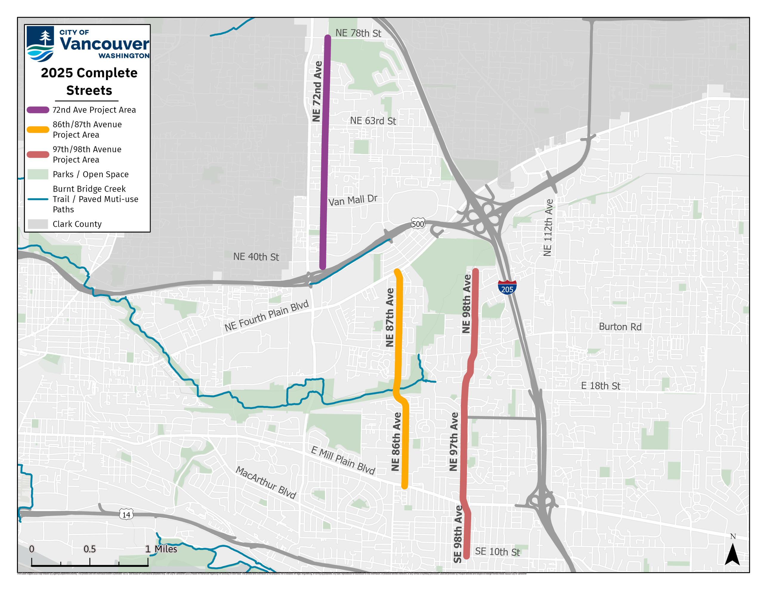
Each of these three corridors provide important connections to community resources including schools, parks, trails, transit, and other transportation corridors, like Fourth Plain Boulevard and Mill Plain Boulevard. These corridors are also identified in the 2024-2044 Transportation System Plan (TSP) as important pedestrian and bike/small mobility network connections for people walking, rolling, biking, using small mobility devices or accessing transit.
The Corridor Projects evaluated how each corridor could better meet the needs of people walking, biking, using a mobility device, accessing transit and driving. In addition to advancing the vision established in the TSP, project goals include:
- Safety: Improve safety and create facilities for all ages, abilities and modes of travel.
- Equity: Engage with members of the community and provide solutions that benefit the full range of community members.
- Climate: Identify solutions that advance climate goals to transition to clean, green modes of travel.
- Connectivity: Implement active transportation connections in alignment with the Transportation System Plan Modal Networks.
Northeast 72nd Avenue
- Project Limits: NE 72nd Avenue from NE 40th Street to NE 78th Street
- Posted Speeds: 25-30 MPH
- Transit Connections: Bus Routes 32 and 78 at NE Vancouver Mall Drive
Design Recommendations
- Lane Reconfiguration: Narrow the vehicle travel lanes to standard widths and repurpose turn lanes to provide bike and small mobility (BSM) lanes and a buffer.
- Crossings: Improve per the design concepts report recommendations.
- Bike / Small Mobility (BSM) Lanes: Add buffered BSM lanes with tubular markers, except Northeast 69th Street to Northeast 75th Street (in Segment 4).
- Signing and Striping: Install leading pedestrian intervals, crossbike markings, two-stage turn bicycle boxes, and no-turn-on-red signs.
- Traffic Calming: Install speed cushions and 25mph posted speed.
- Signals: Upgrade traffic signal hardware.
- Parking Reallocation: All existing on-street parking will be reallocated to create BSM lanes to implement the Transportation System Plan Bike and Small Mobility Network.
Northeast 86/87th Avenue
- Project Limits: NE 86/87th Avenue from E Mill Plain Blvd to NE Fourth Plain Blvd
- Posted Speed: 25 MPH
- Transit Connections: Vine on NE Fourth Plain Blvd and Mill Plain Blvd, Bus 30 on NE Burton Road
Design Recommendations
- Lane Reconfiguration: Narrow vehicle travel lanes to standard widths and repurpose turn lanes to provide BSM lanes and a buffer.
- Crossings: Improve per the design concepts report recommendations.
- Signing and Striping: Install bicycle boxes, crossbike markings, no-turn-on-red signs, sharrows.
- Sidewalks: Some sidewalk gaps may be filled during upcoming projects.
- Traffic Calming: Install speed cushions and 20-25mph posted speed.
- Parking Reallocation: All existing on-street parking between Northeast Burton Road and Mill Plain Boulevard will be reallocated to create BSM lanes to implement the Transportation System Plan Bike and Small Mobility Network.
97/98th Avenue
- Project Limits: NE 98th/SE 97th Avenue from SE 10th Street to NE 39th Street
- Posted Speed: 25 MPH
- Transit Connections: Red Vine BRT on Mill Plain Blvd, Bus 30 on NE Burton Road
Design Recommendations
- Lane Reconfiguration and Bike / Small Mobility Lanes: Narrow vehicle travel lanes to standard widths, increase BSM lane widths to meet standards, and add buffer with tubular markers from Northeast 9th Street to Fourth Plain Boulevard and neighborhood greenway connections on Northeast 9th and 11th Streets.
- Crossings: Improve per the design concepts report recommendations.
- Signing and Striping: Install wayfinding signs, crossbike markings, two-stage turn bicycle boxes, no-turn-on-red signs.
- Traffic Calming: Install speed cushions.
- Parking Reallocation: Some of the existing on-street parking will be reallocated to create BSM lanes to implement the Transportation System Plan Bike and Small Mobility Network.
Community Engagement
Phase 1 (September 2025 – March 2026): To learn how the community currently uses the corridors within the project area, set expectations and share preliminary design considerations.
Phase 2 (April – November 2026): To share design recommendations and priorities informed by the existing conditions analysis, community input from Phase 1, and feedback from the Transportation and Mobility Commission.
Engagement Activities: Interactive maps with survey and design concepts; small group and one-on-one meetings; meetings with neighborhood associations, parent teacher association, and school administration; tabling sessions and canvassing along corridor; Transportation and Mobility Commission meetings.
Communication Methods: BeHeard webpage, direct mailers, project flyers, yard signs, social media posts, e-newsletters to mailing list, direct emails to stakeholders.
Challenges We Heard: Speeding; lack of continuous sidewalks and mobility lanes; lack of crossings and street lighting; drivers not obeying school bus stop paddles, crossings and parking regulations.
Designs Addressing Challenges We Heard: More traffic calming; consistent, separated and protected mobility lanes; crossings and street lighting; increased sight distance at intersections and driveways; signage and striping.
Construction
Construction is expected to occur over many years with multiple projects. In the near term, construction will occur in coordination with the planned pavement work in summer 2026. All other improvements will be implemented in the future as funding is secured. A complete summary of the funded and unfunded recommendations can be found in the Final Design Concept Recommendation Reports.
Evaluation
All Complete Streets projects have an embedded post project evaluation to determine how the added safety and mobility elements function, and to recommend refinements and changes if needed. This is the final stage of Complete Streets projects and occurs in the year following the project’s construction. After the evaluation is complete, road is monitored for safety or other issues in the same manner as all city streets.

