
Upper Main Street Safety and Mobility Project
Overview
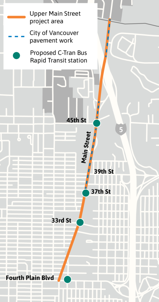
The Upper Main Street Safety and Mobility Project studied how to better meet the needs of people traveling along Main Street from Fourth Plain Boulevard to the northern city limits (just south of NE 63rd Street / Minnehaha Street).
This project is coordinating with planned pavement work in 2026, north of 37th Street to the city limits, and the C-TRAN Highway 99 Bus Rapid Transit Project.
Where are we now?
The recommended improvements between 37th Street and the I-5 interchange will be implemented in summer 2026 through planned pavement work. All other improvements, including those north of the I-5 interchange will be implemented in the future as funding is secured.
Background
Upper Main Street serves as a critical connection for people traveling north-south between the Minnehaha neighborhood and Downtown Vancouver. The corridor connects the neighborhoods of Hough, Arnada, Carter Park, Shumway, Lincoln, Northwest and West Minnehaha. Main Street has been identified as an urban corridor in the 2011- 2030 Comprehensive Plan, and as a commercial spine in The Westside Mobility Strategy. The 2024-2044 Transportation System Plan, which guides how the City improves its streets so that it is safe for everyone to travel, informed the goals for the project, which include:
- Improve pedestrian safety by adding/upgrading crossings and filling sidewalk gaps that improve connections to transit.
- Improve bike and small mobility connectivity by addressing network gaps and connecting to regional trails.
- Explore transit speed and reliability treatments and improve transit stop access in anticipation for C-TRAN’s Highway 99 BRT project.
Community Engagement
Milestone 1 (January – February 2024)
- Purpose: Gather public input on existing safety and mobility issues along Upper Main Street and priorities for improvement.
- Activities: Online survey, mailer, small group briefings, canvassing to businesses, City and C-TRAN email newsletters and social media, and posts to Vancouver Public Schools PeachJar system.
- Common themes: Narrow and missing sidewalks, more marked and safer crossings, gaps in bike and small mobility network, and better wayfinding signage.
Milestone 2 (March – April 2024)
- Purpose: Gather feedback on the proposed corridor improvements for Upper Main Street.
- Activities: Online survey, in-person open house, small group briefings, canvassing to businesses, City and C-TRAN email newsletters and social media, and posts to Vancouver Public Schools PeachJar system.
- Common themes: Support for investments in safety to improve access to schools, local businesses, and transit stops, support for improvements for people walking, biking and rolling and concerns about the improvements potentially causing traffic congestion.
A complete summary of community engagement for this project can be found in the Milestone 1 and Milestone 2 Engagement Summaries.
Design
Recommended improvements along Upper Main Street were developed based on existing City policy, the existing conditions analysis, community feedback and input from the Vancouver Transportation and Mobility Commission. A summary of existing conditions and recommended improvements by Upper Main Street segment are provided below.
Segment 1: Fourth Plain Boulevard to 29th Street
Existing Conditions: Broadway merges with Main Street at 29th Street, poor visibility at 29th Street pedestrian crossing
Recommended Improvements: Add a new marked crossing southside of the 29th Street intersection, replace the northbound and southbound left turn lanes at 29th Street with a long median island and cut throughs for bike and small mobility users, convert access to 29th Street as right-in and right-out for vehicles to deter cut-through traffic and support the future Neighborhood Greenway along 29th Street
Segment 2: 29th Street to 33rd Street
Existing Conditions: Narrow sidewalks, crossing gap that exceeds Pedestrian Crossing Policy of 800 feet, new proposed VINE stations at 33rd Street
Recommended Improvements: Remove one northbound through lane, add a new marked crossing with median island at 31st Street, narrow travel lanes to 11 feet, add a painted shoulder and widen sidewalks in the future to reflect status as Primary Pedestrian Corridor
Segment 3: 33rd Street to 39th Street
Existing Conditions: Narrow sidewalks, crossing gap that exceeds Pedestrian Crossing Policy of 800 feet, new proposed VINE station at 37th Street, narrow travel lanes approaching 39th Street
Recommended Improvements: Remove one northbound through lane, add a new marked crossing with median island at 35th and 37th Streets, widen travel lanes approaching 39th Street to accommodate buses
Segment 4: 39th Street to 45th Street
Existing Conditions: Speeding traffic, narrow or missing sidewalks, new proposed VINE station at 45th Street, narrow travels lanes, identified as part of the Transportation System Plan bike and small mobility network, high number of crashes at 39th Street
Recommended Improvements: Remove one northbound through lane, widen travel lanes to accommodate buses, add a southbound mobility lane on Main Street between 39th and 40th Streets, add a multi-use path between 40th Street and 45th Street, add bike and small mobility improvements along 40th and F Street to connect to Main Street
Segment 5: 45th Street to City Limits (just south of NE 63rd Street/Minnehaha Street)
Existing Conditions: Speeding traffic, sidewalk gap and unprotected bike and small mobility lanes north of I-5 interchange, connection to Clark County
Recommended Improvements: Work closely with Clark County to develop bike and small mobility connection from Discovery Trail at NE Ross Street and Clark County
For more details, view the Existing Conditions Report and Final Recommendations Report.
Construction
Construction is expected to occur over many years with multiple projects. In the near term, construction will occur in coordination with the planned pavement work in summer 2026. All other improvements will be implemented in the future as funding is secured. A complete summary of the funded and unfunded recommendations can be found in the Final Recommendations Report.
Evaluation
All Complete Streets projects have an embedded post project evaluation to determine how the added safety and mobility elements function, and to recommend refinements and changes if needed. This is the final stage of Complete Streets projects and occurs in the year following the project’s construction. After the evaluation is complete, road is monitored for safety or other issues in the same manner as all city streets.
Contact
Maggie Derk, Senior Transportation Planner
maggie.derk@cityofvancouver.us
360-487-7889
